About Us
Central Region PREP
 Central Region Partners for Regional Economic Performance (PREP) network coordinates economic development efforts in the region to promote enhanced customer service to the business community and a comprehensive and efficient economic development delivery strategy. This means there is “no wrong door” for businesses. It doesn’t matter how the company gets into the service provider network it matters how easy and direct it was to get the services and information you require.
Partners
The central prep program’s core partners include the region’s industrial resource centers, the IMC and NEPIRC; the industrial development organizations; SEDA-COG; and the three small business development centers (SDBC’s) located at Penn State, Lock Haven University, and Bucknell University. The service provider network is more than just the four core partners; it includes governor’s action team, PENNTAP, Department of Environmental Protection, Keystone Innovation Zones, Ben Franklin Technology Partners, and the local workforce investment board, to name a few.
Our region
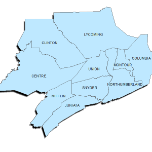
The 10-county central prep region is predominately rural, and is situated in the heart of Pennsylvania. Scattered across the region are a number of mostly small urban centers. The Susquehanna river system, ridges of the Appalachian mountains and the railroads have influenced the region’s growth. Most of the urban centers are found along the Susquehanna and its tributaries, where a significant amount of the region’s economic activity, development, and growth have also occurred in the form of industry, commerce, and services. Included within the central prep region’s 10-county region is 265 municipalities, of which 68 are boroughs, 192 are townships, four are cities, and one is a town.
Centrally located
The region is located within a 360-mile radius of all major population centers in the northeastern united states. Much of this vast consumer market is within four to eight hours driving distance from the heart of the region. A number of major transportation corridors pass through or near the region, further enhancing its strategic location in relation to the eastern seaboard and Midwest markets. In addition, Norfolk Southern, Canadian Pacific/Delaware & Hudson, and the SEDA-COG Joint Rail Authority (SCJRA) provide rail freight service to the region. Interstate 80 bisects the region from east to west. This major highway, running from New York city to San Francisco, is a significant asset because it permits easy access to major metropolitan areas throughout the east coast of the united states. Interstate 99, a portion of which has been constructed through State College, provides for increased north/south interstate access. The US Route 322 highway, which connects the northwestern and southeastern sections of Pennsylvania with the state capital of Harrisburg, is another major transportation artery serving the region. This highway bisects the region and offers access to Harrisburg, state college, and Philadelphia. Us route 11 & 15, the major north-south arteries through central Pennsylvania, stretches from the Mason-Dixon line to New York and stops at the Canadian border.